Advertisement


Private equity has played a significant role in shaping Indi...
In today’s real estate landscape, fitness is often treated...
In this episode of Prop Personalities, we sit down with Hars...
Luxury real estate is one of the most talked-about segments ...
Welcome to Prop Personalities by Prop News Time - a podcast ...
The Ghaziabad Development Authority (GDA) is using drone technology to survey the Madhuban Bapudham housing scheme as part of a land audit, aiming to improve accuracy in land records. The scheme, launched in 2014, covers 1,234 acres and 2,750 plots. The drone survey will help correct mapping errors, including plots mistakenly allocated on crematorium land. Traditionally, manual zonal maps led to discrepancies, but digital integration will enhance precision. GDA officials assured affected allottees of reallocation. This technological upgrade aims to ensure transparency, reduce errors, and establish a reliable digital land record system for improved urban planning and development.
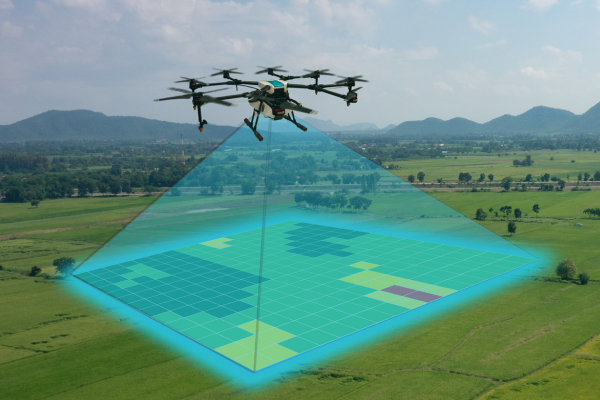
The Ghaziabad Development Authority (GDA) has initiated a drone survey of the Madhuban Bapudham housing scheme as part of its ongoing land audit efforts. The primary objective of this exercise is to ensure accurate documentation of land records using advanced technology. The data collected from the survey will be superimposed onto the zonal map of the township, enabling the authority to maintain a more precise and scientific record of its land holdings. Advertisement


According to GDA Secretary Rajesh Kumar Singh, the Madhuban Bapudham housing scheme was initially conceived in 2004 and subsequently launched in 2014. For the development of the township, approximately 1,234 acres of land were acquired from several villages, including Sadarpur, Mainapur, Morta, Nagla Patt, and Yakutpur. The scheme comprises a total of 2,750 plots, and the GDA now aims to use modern technology for maintaining a systematic and error-free land record.
Singh further highlighted that when the scheme was originally planned, drone technology was not available for such surveys. However, the authority is now employing this advanced method to enhance the accuracy of its land records as part of the broader land audit initiative.
Traditionally, the GDA relied on manually prepared zonal maps, which often contained discrepancies when compared with revenue land records, such as Khasra-Khatauni. These inconsistencies made it challenging to verify and establish the precise boundaries of plots. With the introduction of drone technology, the authority can now determine the exact coordinates of individual plots. The data gathered from the survey will be digitally integrated with the existing zonal map of Madhuban Bapudham, ultimately creating a comprehensive digital land record system that includes maps, precise plot areas, and coordinates.
The need for this technological upgrade became particularly evident after around 300 allottees of the township raised concerns regarding plot allocations. It was discovered that some plots, measuring 60, 90, 115, and 120 square metres, were inadvertently located on crematorium land. However, in the GDA's land survey and records, these parcels had been incorrectly classified as park and park-facing plots.
A GDA official pointed out that such errors underline the importance of adopting modern surveying techniques. Unlike conventional physical surveys, drone technology offers a 3D overview of the land, significantly reducing the likelihood of mistakes. This enhanced accuracy ensures that land records reflect the actual topographical conditions and designated land use, thereby eliminating potential disputes.
In response to the concerns raised by allottees, the GDA's vice chairperson has assured affected individuals that corrective measures will be taken. The authority is currently identifying alternative plots within the township to reallocate to those whose plots were mistakenly assigned to crematorium land.

5th Jun, 2025

25th May, 2023

11th May, 2023

27th Apr, 2023
Advertisement


 Facebook
 Whatsapp